Cape Town Safety on Camera: What Daily Life in the Mother City Really Looks Like
Every year, millions of travelers, digital nomads, and film crews arrive at the foot of Table Mountain, stepping into a visual paradox. Viral social media clips often swing wildly between sun-drenched beach promenades in Camps Bay and stark warnings about South Africa's national crime rates. Municipal monitoring and regional resilience coverage, highlighted in reports like the Cape Gazette Report on coastal civic management, illustrate how modern cities balance infrastructure stress with high seasonal visitor volume. At the same time, with international sporting interest mounting around Cape Town's bid to host a Formula One Grand Prix, the city's civic safety apparatus faces global scrutiny.
Understanding whether Cape Town is safe requires moving past single headlines and examining street-level realities. Safety here is heavily defined by geography, private surveillance architecture, and neighborhood-specific protocols. What a visitor experiences inside the central tourist corridor contrasts sharply with conditions in peripheral precincts just 15 miles to the east.
📌 Key Takeaways:
- Geographic Concentration: Violent crime recorded in official police data remains overwhelmingly concentrated in peripheral township precincts rather than central tourist enclaves.
- Surveillance Infrastructure: Tourist corridors utilize multi-layered private security, drone surveillance, and dedicated improvement district patrols that sharply lower risks of physical confrontation.
- Everyday Operational Rules: Street safety depends on basic habits, including using rideshare services after dark, avoiding visible smartphones along busy transit corridors, and keeping valuables concealed while driving.
The Dual Reality Behind Cape Town Crime Statistics
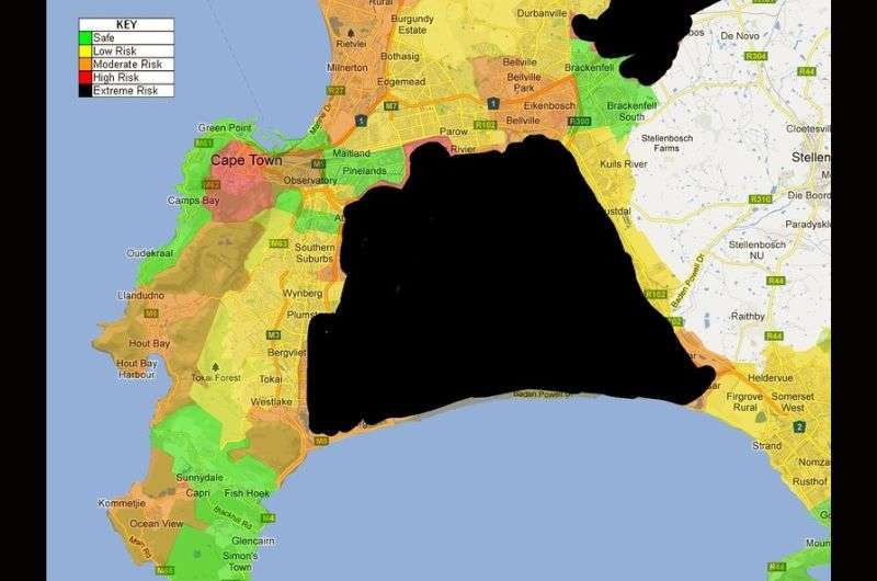
Public perceptions of risk in South Africa often stem from aggregated national figures. When looking closely at local reports released by the South African Police Service (SAPS), a distinct geographical divide emerges. The Mother City operates across two completely separate safety realities dictated by historical spatial planning and socioeconomic division.
The elevated Cape Flats crime rate accounts for the vast majority of Cape Town's violent incidents, notably in precincts like Nyanga, Khayelitsha, Mitchells Plain, and Delft. In these dense, under-resourced residential settlements, gang violence and resource constraints drive the numbers that dominate international headlines. Conversely, central residential and leisure zones show rates of violent interpersonal crime comparable to major European or American transit hubs, with property offenses representing the primary risk.
Recent SAPS quarterly data underscores this divergence. While peripheral districts routinely report high rates of assault and murder, precincts covering the Atlantic Seaboard and the City Bowl report predominantly opportunistic crimes: car break-ins, pickpocketing, and cellphone snatching. Treating the entire metropolitan boundary as a uniform danger zone misreads how security functions across different sectors of the city.
Street-Level Security in the Atlantic Seaboard and V&A Waterfront
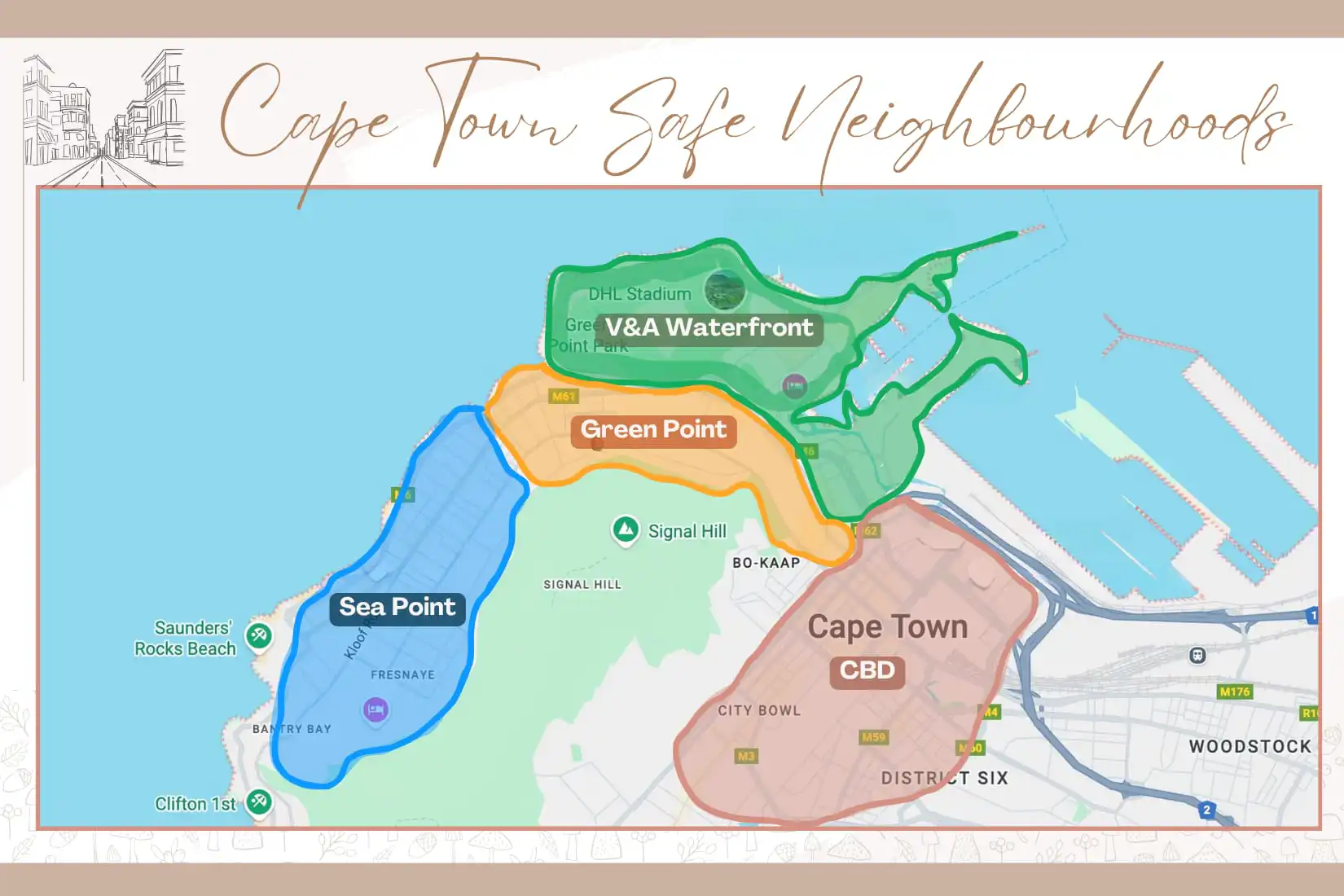
Live camera feeds and pedestrian tracking across the Atlantic Seaboard present an urban rhythm similar to Mediterranean resort hubs. Neighborhoods like Camps Bay, Clifton, Bantry Bay, and Sea Point see thousands of joggers, outdoor diners, and tourists walking unimpeded every afternoon. In these enclaves, private security companies operate alongside municipal Law Enforcement officers, using automatic license plate recognition (LPR) cameras and dedicated vehicle response units.
A key standard for private-public protection is V&A Waterfront security. Welcoming over 20 million visitors annually, the waterfront operates as a self-contained precinct managed by an extensive private security grid. Hundreds of integrated closed-circuit cameras monitor access points, supported by undercover floor wardens, private canal patrols, and strict vehicle screening at parking entrances.
Further west, Camps Bay safety relies on aggressive perimeter defense. Neighborhood watch committees fund high-resolution cameras along Victoria Road and foot patrols along the beachfront strip. While tourists stroll easily between beach bars and cocktail lounges, street-level vigilance remains necessary. Opportunistic scammers occasionally target visitors carrying expensive camera gear or individuals walking alone through poorly lit side streets after late-night dinners.
Neighborhood Risk Profiles Across the Mother City
Evaluating safety in Cape Town requires evaluating neighborhoods individually. Safety varies significantly by corridor, time of day, and mode of travel.
| Neighborhood / Zone | Primary Risk Level | Active Security Infrastructure | Standard Travel Protocol |
|---|---|---|---|
| V&A Waterfront | Very Low | Dedicated private security, 24/7 CCTV, gated perimeter controls | Free pedestrian movement at all hours within precinct boundaries. |
| Camps Bay & Clifton | Low | LPR road cameras, private armed response patrols, beach wardens | Comfortable daytime and evening walking; avoid dark unlit side streets. |
| Cape Town CBD | Moderate | CCID foot wardens, municipal CCTV, SAPS urban patrols | High vigilance for pickpocketing; avoid walking alone late at night. |
| Table Mountain Trails | Moderate | SANParks rangers, aerial drone surveillance, volunteer patrols | Never hike alone; join groups; stick to heavily tracked routes. |
| Cape Flats Precincts | High | Standard SAPS presence, tactical response units | Do not enter without verified local community guides or registered tours. |
Urban Movement in the Central Business District
The Cape Town Central Business District (CBD) acts as the city's commercial and culinary engine, home to high-traffic areas along Bree Street, Long Street, and Kloof Street. Security here is coordinated by the Central City Improvement District (CCID), a non-profit urban management partnership that deploys over 300 public safety officers working 24-hour rotating shifts.
Foot-patrol wardens in high-visibility vests stand on almost every major corner throughout the business day, significantly reducing violent crime. However, petty crime remains a factor. Smartphone snatching by opportunistic operators, distraction theft near ATMs, and aggressive panhandling occur along busy pedestrian arteries, particularly around Lower Long Street after bar hours.
Basic petty theft precautions keep most visits smooth. Avoid walking while looking down at a mobile device, keep bags zipped and positioned across the chest, and decline unsolicited assistance at banking machines. At night, walking just three or four blocks between venues can lead through poorly monitored intersections, making point-to-point transportation the standard choice even for short distances.
Driving Safely, Managing Smash-and-Grab Hazards, and Rideshares
Driving through the Western Cape is straightforward, but urban traffic requires specific safety protocols. When renting a vehicle, understanding rental car safety and smash-and-grab dynamics is essential. Smash-and-grab incidents occur when thieves break a vehicle's side window to snatch bags, phones, or electronics sitting on seats while cars wait at traffic lights or off-ramps.
The most common locations for these incidents are busy transit corridors, including intersections along the N2 highway near the airport, Military Road, and parts of Buitengracht Street leading out of the city center. Drivers prevent these incidents with simple precautions: keep all bags, coats, and devices completely out of sight in the trunk, lock doors immediately upon entering the vehicle, and leave adequate space ahead of your car at red lights to maneuver if necessary.
For visitors skipping car rentals, Uber safety in South Africa offers a reliable, heavily monitored transit network. Rideshares are widely used across Cape Town by locals and visitors alike. To use the service safely, always verify the vehicle license plate, confirm the driver's name before opening the door, and enable the app's four-digit PIN verification feature for every trip. Late at night, hail your ride from inside your restaurant or hotel lobby rather than waiting on the curb.
Managing Table Mountain Trails and Solo Exploration
Table Mountain National Park frames the city, creating an unusual wildland-urban interface. However, wilderness risks and urban crime can intersect on the mountain. Table Mountain hiking safety requires paying close attention to both changing weather patterns and isolated trail crime.
Mugging incidents sometimes target remote trails such as remote paths leading toward Signal Hill, the lower slopes of Devil's Peak, and isolated sections of the Pipe Track. The park authority, SANParks, deploys specialized Sea, Air, and Mountain (SEAM) canine and tactical units, as well as drone surveillance, to monitor high-traffic routes like Platteklip Gorge and Lion's Head. Hikers should avoid setting out alone, never hike with visible luxury electronics or passports, and stick to popular weekend morning departure windows when trails see heavy foot traffic.
For visitors exploring independently, solo female travel Cape Town demands clear spatial awareness rather than avoidance. Thousands of solo female travelers stay in Green Point, Tamboerskloof, and Sea Point each year. Staying safe involves straightforward urban habits: rely on Uber rather than walking after dark, choose accommodations with staffed reception desks or gated perimeters, and opt for registered group outings when exploring mountain trails or visiting coastal towns like Kalk Bay and Simon's Town.
Frequently Asked Questions (FAQ)
Q1: Is it safe to walk through the Cape Town CBD at night?
A1: Walking through the CBD at night carries an increased risk of mugging and cellphone theft once corporate foot traffic clears. While streets with concentrated nightlife like upper Bree Street or Kloof Street remain active, walking across quiet blocks between venues is ill-advised. Use an Uber for point-to-point transit after dark, even for trips under half a mile.
Q2: How secure is the route between Cape Town International Airport and the city center?
A2: The N2 highway connecting the airport to the city center is heavily patrolled by traffic police and surveillance teams, but it borders informal settlements. Stick strictly to the main highway, follow clearly marked city signs, do not take unfamiliar side detours off the freeway, and ensure all luggage is secured out of sight in the trunk.
Q3: Can visitors safely explore townships without an organized tour?
A3: Entering Cape Flats townships like Khayelitsha, Gugulethu, or Nyanga independently in a rental car is unsafe due to complex territorial gang dynamics, confusing informal road layouts, and elevated violent crime rates. Township visits should only be conducted with licensed community guides who live in the area, understand local conditions, and coordinate directly with local community leaders.
Navigating Cape Town Responsibly in 2026
Visiting Cape Town successfully requires setting aside extreme narratives, neither treating it as an open conflict zone nor expecting an untended playground. Millions of international visitors enjoy its beaches, culinary scene, and coastal passes without incident by observing established local guidelines.
Staying safe in the Mother City comes down to respecting spatial boundaries. Base your stay within well-monitored neighborhoods, use app-based transport after dark, keep high-value items out of public view, and treat Table Mountain with the preparation required of any serious wilderness trail. Approach the city with clear eyes and disciplined awareness, and you will navigate one of the world's most dramatic urban landscapes with confidence.