Is Bir Tawil Landlocked? Geopolitical Fact-Check on Maritime Access and the Hala'ib Triangle

Every few years, an adventurous micronation enthusiast or eccentric tourist plants a flag in Bir Tawil and declares the birth of a sovereign state. The romantic fantasy of claiming 795 square miles of unclaimed desert along the African frontier has captivated the public imagination for decades, famously highlighted by Condé Nast Traveler when Jeopardy champion Ken Jennings mused about claiming the patch of no-man's-land. Yet aspiring nation-builders routinely stumble over an immutable physical reality: the territory has no coastline.
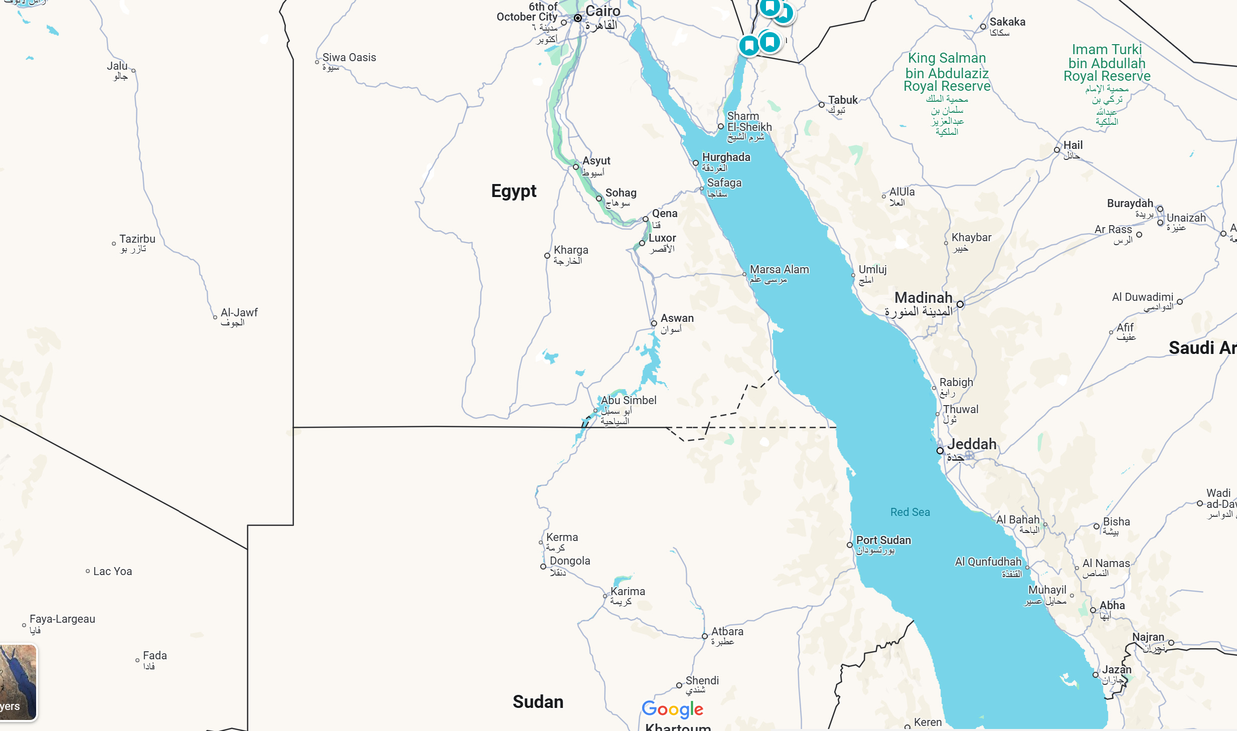
Bir Tawil is entirely landlocked. Hemmed in by rugged desert topography and geopolitical friction, the territory sits dozens of miles inland from the bustling shipping corridors of the maritime world. Understanding why Bir Tawil cannot touch the water requires examining the physical mileage across the Nubian Desert, the legacy of colonial cartography, and the intractable standoff over the resource-rich Hala'ib Triangle.
📌 Key Takeaways:
- Absolute Landlocked Status: Bir Tawil is separated from the Red Sea by roughly 60 miles (100 kilometers) of arid, militarized desert terrain at its closest northeastern corner.
- The Cartographic Inverse: Bir Tawil exists as terra nullius because neither Egypt nor Sudan claims it; claiming it requires conceding the coastal, economically vital Hala'ib Triangle.
- No Maritime Rights: Lacking direct coastal frontage, the territory has zero claim to exclusive economic zones, territorial waters, or access to Red Sea shipping passages under international law.
The Geographic Gap: Measuring the Distance to the Red Sea
Bir Tawil is a trapezoid-shaped expanse of sand and bare rock situated south of the 22nd parallel north. Its northern border stretches approximately 59 miles (95 kilometers) along latitude 22° N, while its southern border spans roughly 29 miles (46 kilometers). At no point does its perimeter make contact with saltwater.
If you stand at the easternmost corner of Bir Tawil (around 34°15' E longitude), the open waters of the Red Sea lie roughly 60 miles (100 kilometers) due east across the Nubian Desert. Reaching major coastal settlements like Marsa Alam to the north or Port Sudan to the south requires traversing hundreds of miles of roadless, hyper-arid terrain. To the east sits the Hala'ib Triangle, a disputed coastal territory of roughly 7,945 square miles that acts as a physical land barrier between Bir Tawil and the maritime shoreline.
This geographic gap eliminates any scenario where Bir Tawil operates a deep-water port or controls naval checkpoints. The territory is stranded in a furnace of gravel basins and wind-scoured granite jebels, completely dependent on the surrounding jurisdictions for any logistical corridor to the coast.
Colonial Borders and the Hala'ib Disconnect
Bir Tawil's landlocked isolation is the accidental byproduct of British imperial administrative adjustments made more than a century ago. Two conflicting colonial documents created this geographic anomaly.
In 1899, the Anglo-Egyptian Condominium Agreement set the political boundary between Egypt and Sudan strictly along the 22nd parallel north. Under this straight-line geometric demarcation, Bir Tawil fell under Sudanese jurisdiction, while the coastal Hala'ib Triangle sat firmly inside Egypt. The line ran straight from the Red Sea coast across the desert, ignoring local tribal grazing patterns.
Three years later, in 1902, the British administration issued a separate administrative boundary. This decree placed the grazing grounds of the Ababda tribe (Bir Tawil) under Egyptian administrative authority, while granting the nomadic Beja tribes access to the Hala'ib Triangle under Sudanese administration. When Sudan secured its independence in 1956, it claimed the 1902 administrative border, which secured the valuable Red Sea coastline. Egypt recognized only the 1899 treaty line, preserving its claim to the same coastal sector. Because both sovereign nations want the maritime wealth of Hala'ib, neither can formally claim Bir Tawil without invalidating their own legal stance on the coast.
| Boundary Agreement | Bir Tawil Status | Hala'ib Triangle Status | Maritime Access Consequence |
|---|---|---|---|
| 1899 Condominium Treaty (Egyptian Position) | Allocated to Sudan | Allocated to Egypt | Egypt retains ~120 miles of Red Sea coastline; Bir Tawil left deep inland. |
| 1902 Administrative Boundary (Sudanese Position) | Allocated to Egypt | Allocated to Sudan | Sudan retains deep-water ports; Bir Tawil remains an inland administrative zone. |
| De Facto Reality (Present Day) | Unclaimed Terra Nullius | Administered / Militarized by Egypt | Bir Tawil remains completely cut off from Red Sea trade lanes by 60+ miles. |
Why Maritime Sovereignty Rights Do Not Apply
Under the United Nations Convention on the Law of the Sea (UNCLOS), coastal states enjoy a 12-nautical-mile territorial sea and an Exclusive Economic Zone (EEZ) extending up to 200 nautical miles for resource extraction. These lucrative maritime rights explain why Egypt has invested heavily in infrastructure throughout the Hala'ib Triangle, maintaining a firm military presence along the port of Hala'ib and Abu Ramad.
Bir Tawil possesses none of these prerogatives. Because it lacks a single foot of shoreline, it generates no territorial waters, no continental shelf rights, and no claims over offshore oil and gas deposits beneath the Red Sea basin. International law provides specific transit rights for landlocked countries through neighboring coastal states, but those frameworks apply exclusively to recognized sovereign states under multilateral agreements. An unclaimed territory held by no recognized government enjoys zero baseline legal standing to request port access, maritime customs exemptions, or pipeline easements from Cairo or Khartoum.
Micronations, Jeremiah Heaton, and the Shipping Route Mirage
The fantasy of establishing an independent country in Bir Tawil reached mainstream headlines in 2014 when Jeremiah Heaton, an American citizen from Virginia, journeyed to the desert basin. Seeking to make his daughter an actual princess, Heaton planted a homemade flag, declared the creation of the "Kingdom of North Sudan," and began seeking international development investment.
Subsequent micronational declarations, ranging from cryptographic testbed concepts like "Free Republic of Liberland" affiliates to environmental reserves, have similarly promoted development plans for the zone. Many pitch renewable energy installations or tax-haven hubs that assume simple links to global maritime supply chains.
These schemes inevitably collide with operational realities. Reaching maritime shipping lanes from Bir Tawil requires crossing highly secure, militarized national borders. Egypt actively patrols its southern frontier to block human trafficking, smuggling, and unauthorized gold mining. Sudan maintains its own military checkpoints across River Nile State and Red Sea State. No vessel can load or unload cargo intended for Bir Tawil without processing through Egyptian or Sudanese customs authorities, paying standard national duties, and complying with sovereign import controls.
Logistical Realities of the Nubian Desert
Survival inside Bir Tawil is governed by geography, not legal theory. The territory is part of the Nubian Desert, an ecoregion characterized by summer temperatures routinely exceeding 115°F (46°C), annual rainfall near zero, and barren rock plateaus punctuated by seasonal dry washes (wadis).
The local population is transient. Groups of Ababda and Bisharin nomads move through the territory following historic seasonal grazing routes, while artisanal gold miners dig makeshift pits in dry riverbeds under dangerous, unregulated conditions. There are no paved highways, electric grids, cellular towers, or permanent water reservoirs inside the borders. Any freight moving between the Red Sea coast and Bir Tawil must navigate shifting sands, treacherous boulder fields, and hundreds of miles of empty desert where vehicle breakdowns can prove fatal.
Frequently Asked Questions (FAQ)
Q1: What is the exact distance from Bir Tawil to the nearest Red Sea coastline?
Bir Tawil's closest northeastern boundary point is approximately 60 miles (100 kilometers) inland from the Red Sea coast across the Hala'ib Triangle. Traveling to an operational deep-water port like Port Sudan requires navigating over 250 miles through Sudanese territory.
Q2: Can someone legally claim Bir Tawil and build a road to the coast?
No. To build a road from Bir Tawil to the Red Sea, an entity would have to build across the Hala'ib Triangle or sovereign Sudanese territory. Both Egypt and Sudan maintain active border controls in these regions, making unauthorized infrastructure projects impossible under international and domestic law.
Q3: Does Bir Tawil have any rivers or water connections leading to the sea?
No. Bir Tawil has no permanent rivers, canals, or navigable waterways. The terrain features only dry wadis that experience flash flooding during rare rainstorms. Water cannot be used for transportation or maritime commerce.
The Geopolitical Horizon
Bir Tawil remains one of the world's few undisputed pieces of terra nullius precisely because it has no coast. Its lack of maritime access strips it of commercial shipping utility, while the surrounding dispute over the Hala'ib Triangle ensures neither regional neighbor will absorb it into their borders.
For geographers and legal analysts, the territory serves as a masterclass in the unintended consequences of colonial cartography. Without an army, a treaty-backed government, or an outlet to the sea, Bir Tawil will remain an isolated island of sand, forever within sight of regional shipping lanes, but entirely unable to touch them.


