Prince William Sound Alaska Travel & Life Guide: Wilderness, Fishing, and Remote Expeditions

Encircled by the jagged, snow-capped Chugach Mountains, Prince William Sound spans over 10,000 square miles of protected fjords, temperate rainforest, and active maritime wilderness along Alaska’s southcentral coast. Recent travel indexes from the Unisba Media Report rank the region among the state’s essential destinations, reflecting a renewed interest in remote coastal expeditions and self-reliant travel. Navigating these waters, however, requires a grounded understanding of weather systems, dynamic ice fields, and distinct gateway communities that operate far off the standard cruise corridors.
Beyond postcard aesthetics lies a complex marine ecosystem and working waterfront economy. Commercial gillnetters share narrow inlets with expedition vessels, while shifting tidewater glaciers redraw navigational charts every season. Whether charting a private boat route, organizing a multi-day paddle, or evaluating the lifestyle of its isolated ports, understanding Prince William Sound demands direct, practical knowledge of its waterways and operational realities.
📌 Key Takeaways:
- Gateway Logistics: Travel routes split sharply across three distinct hubs: road-connected Whittier through a shared rail tunnel, the trans-Alaska pipeline terminus in Valdez, and the roadless fishing community of Cordova.
- Dynamic Maritime Terrain: Glacial retreat in regions like Columbia Glacier and Blackstone Bay creates shifting hazards for vessels, requiring real-time tidal tracking and professional seamanship.
- Subsistence and Sport Regulations: World-class halibut and salmon fishing remains governed by strict localized emergency orders and changing federal retention quotas that impact guided charters and private boats alike.
Gateway Ports: Whittier, Valdez, and Cordova
Prince William Sound lacks a centralized transport hub. Instead, access relies on three coastal settlements, each serving completely different entry points and logistics. The Whittier Alaska port, situated on the western margin, functions as the primary marine departure point from Anchorage. Motorists must pass through the Anton Anderson Memorial Tunnel, a single-lane, 2.5-mile dual-use engineering structure alternating between vehicle traffic and Alaska Railroad trains on a rigid 30-minute schedule. Whittier provides direct access to western passages and granite-walled fjords, catering largely to fast day tours and independent boat launches.
On the northeastern side sits Valdez, reachable by driving the Richardson Highway past Thompson Pass. Valdez serves as the heavy-duty operational base for long-range marine traffic. It hosts commercial fleets, industrial support vessels, and private operators running Valdez boat charters into eastern passages, outer islands, and remote bays. The port is sheltered, deep, and equipped with comprehensive marine repair services, making it the preferred launching pad for extended offshore crossings.
Cordova anchors the southeastern corner, isolated from the North American road grid. Accessible only via the Alaska Marine Highway ferry system or regional air carriers into Merle K. (Mudhole) Smith Airport, Cordova remains driven by commercial fishing rather than mass tourism. Flanked by the sprawling Orca Bay and the Copper River Delta, it provides a functional base for sea-based scientific fieldwork, independent wilderness packing, and wild sockeye salmon harvesting.
Glacial Systems: Columbia Glacier and Blackstone Bay
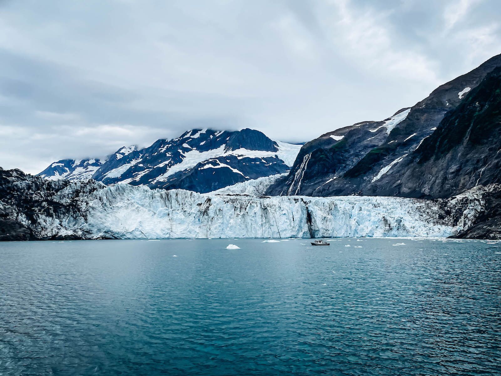
Over 150 glaciers descend from the Chugach Range into saltwater, creating one of the dense collections of tidewater glaciers on earth. These ice masses behave differently based on depth, bedrock topography, and microclimates. Columbia Glacier, one of the most studied maritime glaciers in North America, has retreated over 12 miles northward since the early 1980s. The massive collapse of its terminus has left a wide debris field of brash ice and tabular bergs drifting across Columbia Bay, challenging small motorcraft and requiring skippers to maintain vigilant watch for submerged growlers.
To the west, Blackstone Bay presents an enclosed fjord system flanked by vertical granite walls, hanging ice falls, and two active termini: Beloit and Blackstone glaciers. Because it sits within reasonable boating distance from Whittier, it serves as a primary destination for structured sea kayaking expeditions and small-craft day runs. Calving events generate sudden, localized wake waves that bounce off steep fjord walls. Experienced paddlers camp above highest-tide marks and secure their hulls to dense alder trunks rather than exposed gravel bars.
| Departure Port | Primary Glaciers & Waterways | Transit Infrastructure | Best Suited For |
|---|---|---|---|
| Whittier | Blackstone Bay, Passage Canal, Harriman Fjord | Highway + Shared rail/road tunnel (Toll) | Day tours, close-range sea kayaking, water taxis |
| Valdez | Columbia Glacier, Valdez Arm, Port Fidalgo | Richardson Highway (Year-round road access) | Offshore charter fishing, long-range private cruising |
| Cordova | Orca Bay, Hawkins Island, Copper River Flats | State Ferry (AMHS) or commercial flight only | Wildlife photography, commercial fisheries, eco-lodges |
Marine Wildlife Encounters and Ecosystem Patterns
Prince William Sound acts as a nutrient-rich mixing basin where cold, oxygen-heavy currents converge with glacial meltwater. This hydrology sustains dense populations of plankton and baitfish like herring, anchoring the marine food web. From May through September, humpback whale watching peaks along outer waterways such as Montague Strait and Hinchinbrook Entrance. Pods of resident fish-eating orcas share these passages with transient mammal-hunting killer whales, the latter patrolling near sea lion haul-outs and protected rocky lagoons.
In addition to megafauna, seasonal bird migrations transform the sound into an active flyway. Field updates from Wired2Fish document the sweeping aerial skydances of thousands of migratory shorebirds and seabirds descending on the sound's shallow mudflats and tidally exposed channels. Tufted puffins, black-legged kittiwakes, and bald eagles nest in high concentrations along sheer island cliffs. On the water's surface, southern sea otters, which have recovered substantially over the last four decades, forage for crabs, clams, and urchins across protected bays, often resting in large communal groups within dense kelp beds.
Responsible marine wildlife tours operate under strict federal guidelines mandated by the Marine Mammal Protection Act. Vessels must maintain at least 100 yards of clearance from humpback whales and adjust throttle speeds to avoid disruptive wake near seal pupping icebergs. Operating ethically inside this natural corridor requires quiet drifting and indirect approaches that do not alter animal behavior.
Backcountry Waters: Halibut and Salmon Fishing Realities
Anglers consistently rank southcentral Alaska among the world's premier sport fisheries, a status reaffirmed in fishing destination overviews compiled by islands.com. The sport fishing sector in the sound divides into distinct seasonal waves. May marks the opening of targeting pacific halibut in deep underwater trenches ranging from 150 to 350 feet. Lingcod opens on July 1, alongside pelagic and non-pelagic rockfish species found across submerged pinnacles and steep offshore drop-offs.
Salmon runs hit the sound in rapid succession. Sockeye push toward regional rivers in late spring, followed by massive aggregations of pink salmon in July and aggressive silver (coho) salmon from August into September. However, harvesting fish here requires close attention to logistical preparation. In a book excerpt published by the Alaska Sporting Journal, seasoned outdoors writers illustrate how unpredictable sea swells, gear limitations, and poor planning can quickly turn high expectations into a harsh lesson on subarctic waters. Tides fluctuate by as much as 15 feet, producing powerful ripping currents that rip light anchors out of soft mud and drag lightweight sinkers completely away from the bottom strike zone.
Fishermen operating without private vessels rely on remote water taxi access. These landing-craft-style vessels drop parties onto wilderness beaches with inflatable rafts, camping gear, and portable bear-resistant food storage. Water taxi operators maintain strict scheduling windows; missed pickups caused by sudden storms often require parties to stay stranded onshore for multiple extra days, underscoring the absolute necessity of carrying surplus dry food, satellite communication hardware, and functional cold-weather bivy gear.
Living and Working Along the Chugach Maritime Rim
Human existence in Prince William Sound is defined by maritime trades and the surrounding Chugach National Forest, which covers 5.4 million acres across southcentral Alaska. The communities that line these channels maintain deep ties to the water. In Cordova, seasonal fishing openings dictate town life. When the commercial drift-fleet heads out into Orca Bay for sockeye or king openings, onshore businesses adjust their operating hours to coordinate with the tides and unloading schedules at the processing plants.
Living here year-round means managing intense coastal weather patterns. The sound receives between 100 and 180 inches of annual precipitation depending on localized mountain proximity. Rain turns into heavy, wet snow along sea level throughout late autumn and winter. Roof shoveling, boat harbor bilge inspections, and maintaining marine generators are standard routines of everyday residency. Houses are built on reinforced pilings to handle marshy ground and seismic tremors, while heating demands rely heavily on imported fuel oil, cordwood, or localized hydroelectric cooperatives.
Modern telecommunications, particularly low-earth orbit satellite broadband, have allowed remote business owners, lodge operators, and field researchers to remain connected while stationed at isolated outposts like Chenega or Tatitlek. Despite modern technology, coastal life continues to require personal resilience, reliance on neighbors, and respect for shifting weather fronts that can pin down boats and floatplanes for days at a time.
Frequently Asked Questions (FAQ)
Q1: What is the optimal window to visit Prince William Sound?
A1: The primary operational season runs from June 1 through August 31. During these months, daytime temperatures hover between 55°F and 68°F, day tours run regularly, charter fleets operate daily, and salmon runs draw both sport anglers and brown bears toward coastal creeks. May and September offer thinner crowds, but travelers face shorter daylight hours, shuttered seasonal businesses, and increasingly frequent maritime gales.
Q2: How rough are the waters inside Prince William Sound for small craft?
A2: While outer waterways like Hinchinbrook Entrance face the full force of Gulf of Alaska swells, the sound's interior fjords, bays, and passages are generally sheltered by large barrier islands like Montague and Hinchinbrook. However, steep katabatic winds can sweep off ice fields without warning, kicking up steep 3- to 6-foot chop within minutes. Small craft and sea kayaks must continuously monitor VHF marine weather radio broadcasts.
Q3: Do I need a permit to camp within the Chugach National Forest surrounding the sound?
A3: Most dispersed backcountry beach camping along public coastal shorelines within Chugach National Forest does not require an advance permit for individual recreation. However, you must carefully verify land ownership before pitching camp. Extensive parcels throughout Prince William Sound, including portions of beaches, islands, and historical sites, belong to Alaska Native corporations, requiring land-use permits for recreational shore landings.
Preserving the Sound's Maritime Legacy
The operational landscape of Prince William Sound continues to balance conservation imperatives with resource extraction and visitor expansion. The sound has substantially recovered from past ecological challenges, yet modern pressures include addressing changing sea surface temperatures, maintaining sustainable harvest quotas for sport and commercial fisheries, and protecting critical marine habitats from overuse. Local harbor masters, commercial skippers, and backcountry guides increasingly advocate for reduced wash speeds near fragile shorelines and low-impact Leave No Trace protocols for island expeditions.
Whether navigating an expedition vessel through the drift ice of Columbia Bay or sea kayaking along the sheer granite corridors of Blackstone Bay, entering Prince William Sound demands humility before subarctic geography. Its network of deep channels, working harbors, and massive ice walls remains one of the few wild coastal realms where the cadence of natural systems decisively governs everyday life.